OREGON MINES
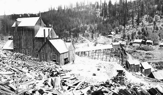
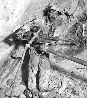
Mammoth Mine - Elkhorn Mnts. near Sumpter, OR
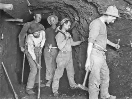
In the early 1850s, prospectors first discovered gold in the southern region of what was then Oregon Territory. In the 1860s, gold miners moved into eastern Oregon. In both areas, corporations with outside investors soon replaced small and independent mining operations. Workers used gravity-fed, high-pressure water to remove entire hillsides, drastically altering landscapes and destroying fish habitat in streams and rivers. They also tunneled underground for gold, silver, and copper.
In Oregon, miners also found mercury, then called quicksilver. Mercury was one of several toxic chemicals, including chlorine and arsenic, that companies used to extract minerals from rock and dirt.
In January of 1852, two mule packers, John R. Poole and James Cluggage, were hauling supplies from the Willamette Valley in the Oregon territory to Sacramento, California. They decided to set up camp for the night along a foothill. Needing water for their animals they found a promising spot and started digging a hole. While digging they noticed a gold color in the hole. Sorting out the debris they realized they had just struck gold. John R. Poole and James Cluggage had accidentally stumbled onto the largest gold strike in Oregon’s history.
They immediately filed claim on the land located on Daisy Creek and named it ‘Rich Gulch’. They also filed claims along Jackson Creek, where large amounts of course placer gold was found. Once the news got out,thousands of men from all over the country pulled up stakes, left loved ones behind and moved to Southern Oregon for a chance to strike it rich.
James Cluggage filed a donation land claim on 160 acres and John R. Poole filed claim on 306 acres. With a section of their land the partners then went about setting up a town site, naming it Table Rock City. Poole and Cluggage became wealthy leaders in their community. Table Rock City later changed its name to Jacksonville. Soon Jacksonville became the largest town north of San Francisco, California. During the late 1800s C.C. Beekman's Bank in Jacksonville was the only bank in America known to charge its clients for banking with them and not paying interest on accounts. The Beekman Bank scales weighed in over ten million dollars worth of gold.
From this initial discovery discovery on Jackson Creek, the discoveries rapidly extended east and west until all the mountain regions of Jackson, Josephine and Curry Counties had been thoroughly explored, and many millions of dollars taken out. Gold was discovered first in Josephine County by a party of sailors who deserted their ship at Crescent City on hearing of the discovery in the Rogue River valley, and made their way across the mountains to the head waters of the Illinois river, and commenced prospecting in the vicinity of the old mining camp of Waldo. Here they struck "pay dirt," and so rich as to attract many others to the place, which from that date on went by the name of "Sailor Diggins." And in Josephine County the first mining district in Oregon was organized. Prior to this date, some Oregonians going down to the California mines did find colors of gold at the old fort of Rogue River down below the point where the town of Gold Hill is now located. But as it was not worth working it was never reported as a discovery.
Early mining activity in Oregon focused on easily accessible placer deposits, unconsolidated sand, gravel, and minerals that were exploited by panning or hydraulic mining. Many of these were quickly exhausted, though, forcing the industry to switch to lode deposits, which required expensive equipment and an organized workforce to mine. The first lode deposits in the state were developed in 1859, when southern Oregon’s Gold Hill Mine began operations. Investors began financing lode mines in northeastern Oregon in the 1860s. By the turn of the century more than half the gold produced in Baker County came from lode mines.
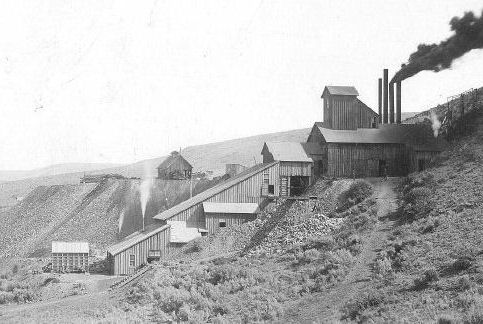
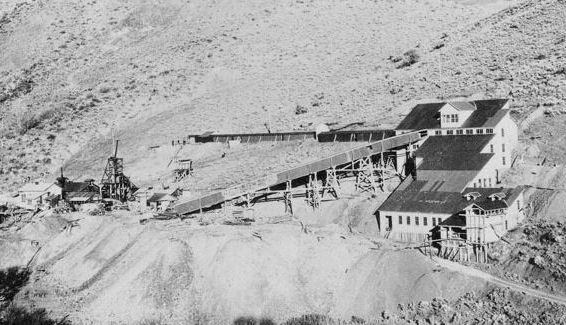
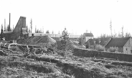
Lode deposits were first discovered in the Balm Creek area in 1907. By 1920, the workings in this area, including the Mother Lode Mine, had produced more than $78,000 worth of gold and silver. In the mid-1920s high-grade copper ores were discovered and developed by the Oregon Copper Company, which consolidated the Mother Lode Mine with several other workings in the area. There were two shafts and three tunnels in operation by the mid-1930s, as well as a 100-ton flotation mill, shown in this photo. Flotation processing uses water mixed with chemicals that react with valuable minerals, making them easier to extract. The tailings, unwanted leftovers, are then dumped into a holding pond.
From 1907 to 1939, the Mother Lode Mine produced more than 8,100 ounces of gold and 4 million pounds of copper, worth approximately $405,000. The mine ceased production in the late 1930s due to falling copper prices and rising operational costs.
Baker County was the center of eastern Oregon gold mining activites. Within Baker County, which was at that time larger than today's county, were several mining districts. These included the Baisley-Elkhorn, district which was located 16 miles northwest of Baker City. Directly west and across the ridge from the Baisley-Elkhorn, commences the Rock-creek district,. The district includes the mountain region between Baisley-Elkhorn and Cracker creek, covering a distance of six miles. West of Baker City is the Cracker Creek district, with veins running north and south. The district is four miles wide and 18 miles long. Still further west of Baker City is the Cable Cove district. The veins run north and south, the belt embracing four miles in width and 20 miles in length. Southwest, about 40 miles from Baker City, commences the Bonanza district, containing east and west veins. The Gold Ridge district is located about 35 miles southeast from Baker City. Rich tellurium ore is found in this range of mountains, the Gold Ridge and Gold Hill being the two most noted mines in the district. Forty miles southwest of Baker City is the Rye Valley district.
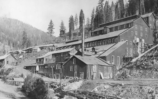
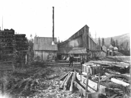
Another Baker County gold mining district was at Cornucopia, some 50 miles east of Baker City in the Wallowa Mountains. Baker County had teemed with miners in the 1860s, and a new series of excitements followed the arrival of the railroad in 1884. The Oregon Gold Mining Company in Cornucopia reported a 20-stamp mill in 1889. This was an industrial operation that required substantial buildings and heavy machinery. The lumber used to build this structure was milled in Baker County, and like the machinery, was taken to Cornucopia by horse-drawn wagon. The steeply-pitched roofs helped shed the heavy snowfall found at this 7,000-foot elevation.
Mining-related buildings in the vernacular style were common in the gold-bearing areas of Baker, Jackson, Josephine, Lane, and Douglas counties. Other mining operations, each requiring various structures to extract and process the product, have included coal in Coos County, nickel in Douglas County, copper in Baker County, and iron near Lake Oswego. The mines at Cornucopia were developed beginning in 1885. Like many gold mining operations, the activity fluctuated widely, influenced by the quality of the ore, operating costs, the national economy, and gold prices. Cornucopia’s most prosperous years, during the 1920s and 1930s, came long after the initial discoveries. The Baker Mining District, in Baker County, in 1897 yielded gold from 313 gold mines and claims, in all stages of development, worth over $3,000,000.
In 1862, while the Civil War was still in it's infancy, five men (Hugh Asbury, John Reel, Fletch Henderson, Bill Flanagan, and Dick Johnson) from South Carolina were traveling on their way to the California gold fields. They camped near what is now known as Cracker Creek. They made the first gold discovery while panning the gravels along the creek. It was decided they would stay and work in this area rather than continuing on to California. They built a primitive small cabin, between McCully Creek and Cracker Creek, naming it Fort Sumter after the South Carolina fort of Civil War fame.
Growth came slowly to Sumpter; its only connection to the outside world was the wagon road winding over and through the hills to Baker City, nearly thirty miles away. This wagon road became the early stage route that connected all the boom-towns and mines in the area. During that time Placer Mining was going strong. The placer miners discovered most of the gold-bearing quartz ledges in the area and hard rock mining began in the Sumpter Valley and the surrounding mountains.
About 1895 Sumpter began to grow due to the changes in mining technology and new methods to chemically extract the gold from its alloys. In 1897 the Sumpter Valley Railway extended track into Sumpter, population 300, and the boom was on! The US Census of 1903 counted over 3500 registered voters. They did not, however, count the women, children or the Chinese! The population was most likely considerably larger.
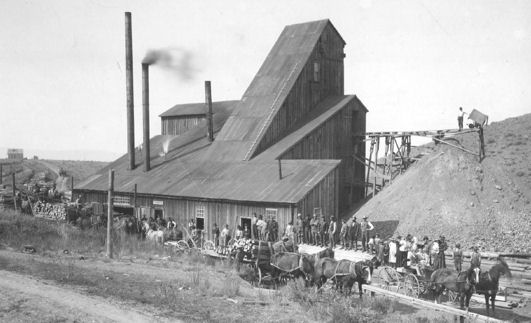
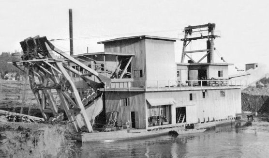
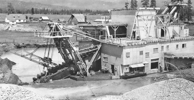
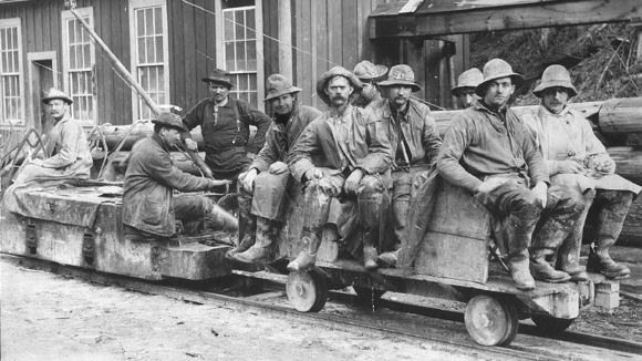
In 1899, the Sumpter Valley Railway delivered as much as six carloads of mining machinery each day and hauled six hundred car loads of timber each month to its mills in Sumpter and Baker City. There were seven daily stage lines, located in Sumpter, connecting the surrounding mining camps and towns. Millions of dollars in gold were extracted from the mines around the Queen City, with the going wage for miners at $4.00 per day for a twelve-hour shift. The peak came in 1900 with an output of $8,943,486 from thirty-five mines. In addition to the gold mines, three gold dredges worked the Sumpter area from 1913 until 1953.
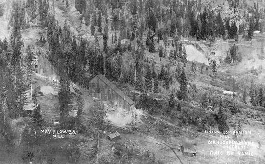
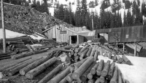
Mayflower & Union Companion Mill Cornucopia, Baker Co., OR
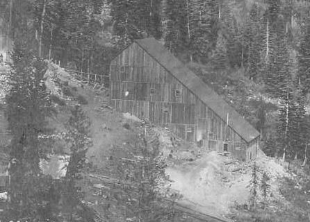
Mayflower Mill - Cornucopia, Baker Co., OR
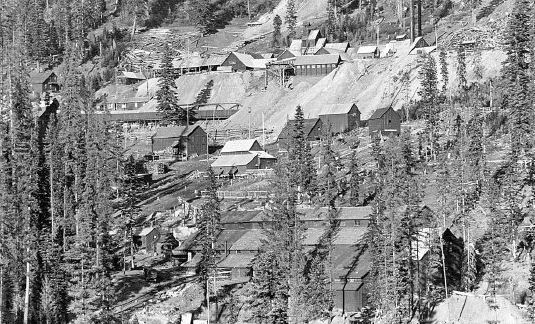
Cougar-Independence Mine - Granite District
2.25 miles N. of Granite,OR
Eureka & Excelsior Mine - Baker Co., OR
Argonaut Mine - Sumpter, Baker Co., OR
White Swan Mine.- 9.3 miles ESE of Baker City, OR
Poorman-Balm Creek Mine - 20 miles NE of Baker City, OR
Virtue Mine.- 6.6 miles E. of Baker City,OR
Powder River Gold Dredging Co. Dredge #2 - Sumpter, OR 1915-1923
Dredge #3 (Sumpter Valley) . Dredge near Hawley ranch
Bonanza Miner - Greenhorn, Cornucopia District, Baker County OR
Ben Harrison Mine. - Greenhorn District - 4.7 mi. NW of Greenhorn City, OR
Miller Mt. Placer Mine - Grant Co., OR
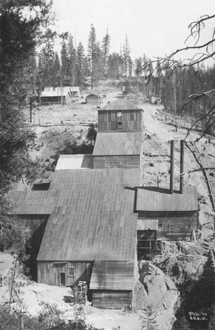
IXL Mine. Hoist, mill, and cyanide plants - Greenhorn City, OR
IXL Mine - Greenhorn City, OR
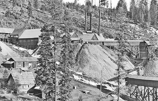
Cornucopia Mine - Baker County,OR
Columbia Mine. - Cracker District - Bourne, OR
Columbia Mine. - Cracker District - Bourne, OR
Superior Coal Co. - OR
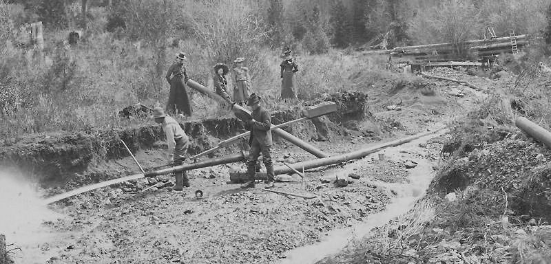
Small Oregon Hydraulic Gold Mining Operation - 1885
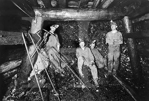
Coal Miners - Coos Bay, OR